Multiple Modalities
What are multiple modalities? Educators make content accessible to different learners by purposefully selecting and combining different modalities (audio, visual and/or kinesthetic) to represent ideas.
What does the use of multiple modalities look like in practice? Within a given lesson, educators may add in two or more of the following elements:
- include physical activities that get students moving,
- tell stories or explain ideas orally
- add in visual representations of ideas such as video clips, photos, and maps to orient students to people and places
For example, when sharing data or evidence to back a claim, include a labeled chart, diagram or graph as well as an oral explanation that guides learners toward important information.
The examples below highlight how educators use different modalities to teach engaging content.
Mote Marine Laboratory Women in STEM series
This video is part of a five-episode STEM series for students in grades 5-9. It features amazing women researchers working in marine science. Each recording includes science demonstrations and bonus activities that reinforce concepts covered during the programs. This program, “Making Music with Marine Animals”, features Dr. Katie McHugh, a Staff Scientist employed by the Chicago Zoological Society and based at Mote Marine Laboratory as part of a partnership to engage in dolphin research, education, and conservation action.
In this example, Dr. McHugh explains that dolphins have unique whistles for identification. She then shows a visual representation of several unique dolphin whistles while playing the audio at the same time. She also interprets what students are hearing and seeing to enhance understanding.
This unique element of the program allows students to both hear and see dolphin whistles, helping them to really understand the unique features of each whistle.
“Nature Tracking in the Forest” is a virtual ecosystem exploration program for grades 4-12 where students collect and evaluate evidence to develop explanations about what animals are present in the area and what behaviors they have been engaging in. This program utilizes visual (satellite images/ google earth) and auditory (narration) modalities to help students learn geography and get to know a particular place.
The educator uses multiple modalities to orient the students at the beginning of the lesson. She uses Google Earth to zoom into a view of the students’ school and pauses on the satellite image of the school before asking the class if the site looks familiar. The educator then uses Google Earth to simulate travel from the school to Shaw Nature Reserve. She compares the Google Earth travel to an eagle soaring over the clouds. The educator provides an overview of characteristics of Shaw Nature Reserve as she travels over space in Google Earth, identifying the various ecosystems (prairie, pond, forest, river) that are shown on the satellite image before “arriving” at the Shaw Nature Reserve Learning Campus.
The educator continues to use multiple modalities throughout the program. As the educator spots new evidence of animals in the forest ecosystem, she uses her camera to zoom in and pan around so that the students can make their own observations from multiple angles. For example, the educator approaches a tree and brings the camera really close to the trunk to show students what the tree’s normal bark looked like. She explains that there is a clue on the tree before scanning the camera down the length of the tree. By using this live video interaction, the educator provides an additional way for students to explore the site aside from photos or curated video clips.
Grand Canyon National Park
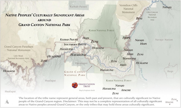
The Land That Shapes Us program for students grades 6 and up explores land use and rights at Grand Canyon National Park. Students investigate the historically tenuous relationship between the National Park Service and Grand Canyon's 11 traditionally associated tribes. Students are asked to consider how the past influences the present and what actions can help affect positive change in the future.
Grand Canyon region

To depict the Grand Canyon landscape and its importance to many different groups of people, this program uses maps of indigenous territories, images of the canyon through many different eras, descriptions of hiking on trails in the canyon, a video interview with a member of the Hopi tribe, and audio recording from a news story of the 100 year anniversary of Grand Canyon NP.
While participating in this program, the students can both see and hear a variety of voices and images that enhance their understanding of this special place and how different people feel about it.


